S.E. Robinson, Jr.
@SERobinsonJr
Geeking on Space, EVs, Tunnels, BCIs & AI. Writer/Owner of @ELONCHRON — daily easy-to-read chronicle on Musk companies. Subscribe and Support the content!
Joined March 2020
620 Following 55.1K Followers
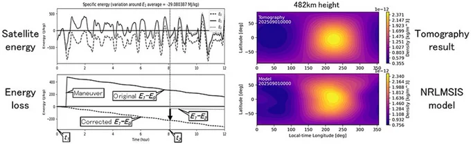
STARLINK: Using SpaceX’s public high-resolution ephemeris data (position and velocity vectors) from roughly 1,200 Starlink satellites, Kyoto University researcher Mamoru Yamamoto published "Tomography of thermospheric density from Starlink Ephemeris: initial report" on July 30th in Earth, Planets and Space.
At 482 km altitude and 53° inclination, the team measured energy loss from atmospheric drag. They applied spherical-harmonic tomography to produce the first latitude-longitude density maps of the thermosphere near 500 km for September 1–7, 2025.
Results averaged 0.95 times independent ESA SWARM measurements (range 0.6–1.2 across 19 cases) and matched NRLMSIS 2.1 model features.
An earlier 2026 paper by Yamamoto and Takuya Sori used TLE data and identified density spikes on October 8, 11, and 18–20, 2024, mainly tied to geomagnetic storms.
Better knowledge of upper-atmosphere density lets operators predict satellite orbits more accurately and reduce the risk of collisions. With the measurements he created the first detailed maps showing air density across different latitudes and longitudes at roughly 500 km altitude.
More Starlink news in today's EC below!
Show more